このページでは地震から離れて,「風」の話をします.中学校理科の気象を勉強する分野で「海風,陸風」という内容があります.晴れた日の日中は,あたたまりやすい陸地で上昇気流が発生すために海から陸へ風が吹き(海風),夜間は冷えやすい陸地で下降気流が起きて陸から海へ風が吹き出す(陸風)というものです.(図1,2)
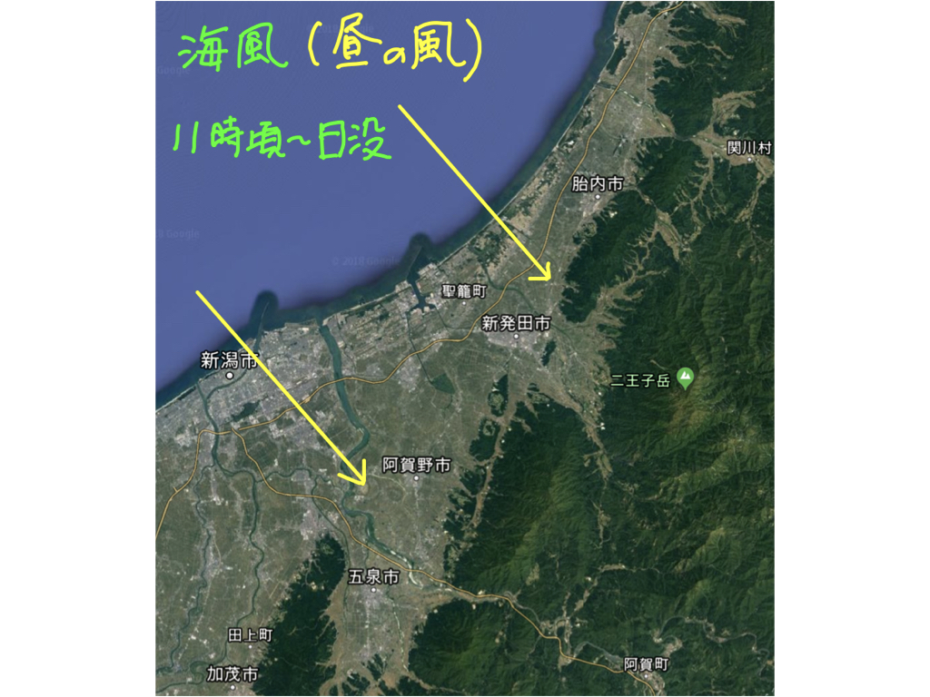
図1.陸地で上昇気流が起きるために海風が吹く.
Figure 1. Sea wind occur because of rising air currents over land.
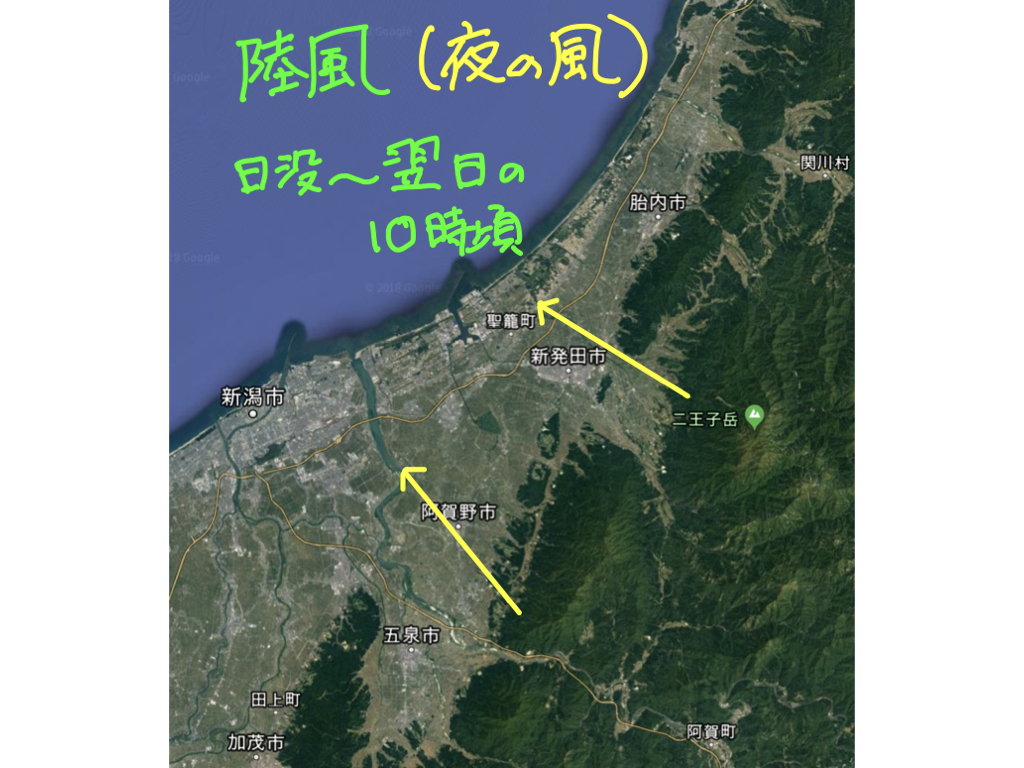
図2. 陸地では下降気流が起きて陸風が吹く.
Figure 2. On land, downdrafts occur and land wind blow.
|
海陸風は局地的に生じる大気の循環です.いつでも起きる現象ではなくて,「穏やかに晴れた日」でないとはっきりわかりません.このような日の日中,内陸の地表付近の空気が太陽放射で暖められて上昇します.数百mほど上昇した空気が,この高さの上空を海側へ移動し,比較的冷たい海で冷やされて海面まで下降します.この空気は地表付近の低空を上空とは反対方向の海側から陸側へ移動し,上昇気流が生じて空気が足りなくなった陸地に引き込まれて海風となります(図3 左).
反対に,夜は比較的暖かい海で上昇気流が生じます.やはり数百mほど上昇した空気は陸側へ移動し,放射冷却で冷えた陸地で下降気流となります.冷えた空気は地表に沿って,上昇気流が生じて空気が足りなくなった海へ向かって移動する陸風になるのです(図3 右).
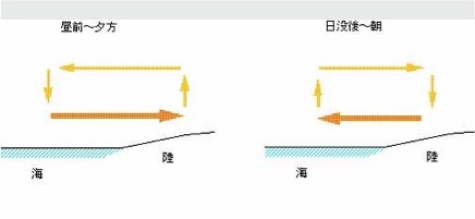
図3.日中,内陸の地表付近の空気が太陽放射で暖められて上昇します.数百mほど上昇した空気が,この高さの上空を海側へ移動し,比較的冷たい海で冷やされて海面まで下降します.この空気は地表付近の低空を上空とは反対方向の海側から陸側へ移動し,上昇気流が生じて空気が足りなくなった陸地に引き込まれて海風となります(左).夜は比較的暖かい海で上昇気流が生じます.やはり数百mほど上昇した空気は陸側へ移動し,放射冷却で冷えた陸地で下降気流となります.冷えた空気は地表に沿って,上昇気流が生じて空気が足りなくなった海へ向かって移動する陸風になります(右).
Figure 3. During the day, the air near the surface inland is warmed by solar radiation and rises. Air that rises several hundred meters above this height moves toward the sea, is cooled by the relatively cold ocean, and then falls to the sea surface. This air moves at a low altitude near the earth's surface from the sea side to the land side in the opposite direction from the sky, creating an updraft that is drawn into the land where there is insufficient air and becomes a sea wind (left). At night, updrafts occur in relatively warm oceans. After all, the air that has risen several hundred meters moves toward the land and becomes a downdraft over the land, which has cooled due to radiation cooling. The cooled air becomes a land wind that moves along the earth's surface, creating updrafts and moving toward the sea, where there is insufficient air (right).
|
図4に,新潟市中央区のある晴れた日の一日の気象の変化を,気象庁のデータベースにより紹介します.中学校の理科では,海風と陸風が日の出時と日没時に入れ替わると教えますが,この日は正午頃になって,陸風から海風に変わっています.新潟市の場合,午前10時頃から12時頃の間に変わるようです.海風の風向は,そのときの気圧配置の関係で,北寄りから西寄りまでいろいろです.この日のように,陸風と海風の方向が180度ではなく90度くらいの関係になることもしばしばです.
閑話休題です.この地方では,児童生徒の朝の登校時はまだ陸風が吹いています.ですから,自宅が学校よりも海側にある児童生徒は風に向かって登校します.そして下校時は日没前の海風ですから,また,元気よく風に向かって帰宅するのです.
さて,このことは太平洋側ではどうなるのでしょう.図5は岩手県釜石市の同月同日のデータです.新潟市の場合と対称的になっていることがわかります.「反対の反対」ですから,こちらでも,自宅が学校より海側にある生徒が登校時,下校時ともに元気よく風に向かうことになるのです.
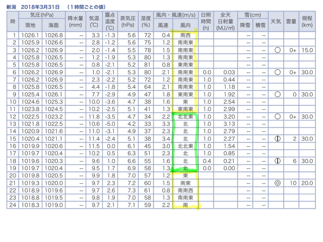
図4. 黄色枠が陸風で緑色枠が海風.正午頃と午後6時頃に変化しています.
Figure 4. The yellow frame is land breeze and the green frame is sea breeze. It changes around noon and around 6pm.
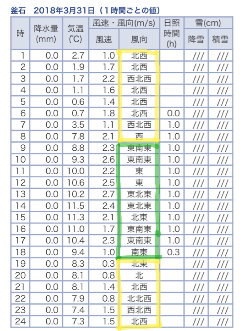
図5. 黄色枠が陸風で緑色枠が海風.午前9時頃と午後6時頃に変化しています.
Figure 5. The yellow frame is land wind and the green frame is sea wind. It changes from around 9am to around 6pm.
|
・地震地学のほかに(プロフィール、地学全般その他)に戻る
|
|