ダシの風,ヤマセ,アイの風
日本列島を覆っていた移動性高気圧が東へ移り,日本海に低気圧が現れると、この低気圧に向かって東風が吹きます.日本海側の地方で,この東風に海陸風のうちの陸風が合わさることが,また太平洋側ではこの東風に海風が合わさることがあります.どちらも強い風が吹くことになります.この風を地方によってはダシの風,ヤマセ,あいの風などと呼んで恐れています.
とくに図1で示した北から荒川,胎内川,阿賀野川が山地から平野へ出るところでは,谷地形で気流が「集束」して猛烈な風になることがあります.そのため,家の立地条件によっては,屋敷林は冬の季節風を防ぐ西側よりもダシの風を防ぐ東側を厳重にします.
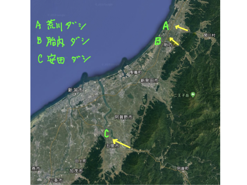
図1. 荒川(A),胎内川(B),阿賀野川(C)の平野側出口が狭隘な谷になっていることに注目してください.東風はここで集束して平野側に突風をもたらします.阿賀野川の出口には瓦やヨーグルトの生産で知られる阿賀野市保田地区(旧安田町)があり,ヤスダのダシの風と呼ばれています.
Figure 1. Notice that the plain side exits of the Arakawa (A), Tainai River (B), and Agano River (C) are narrow valleys. East winds converge here and bring gusts to the plains. At the exit of the Agano River is the Yasuda district (formerly Yasuda Town) of Agano City, known for its production of roof tiles and yogurt, and is known as the Yasuda Dashi no Kaze.
|
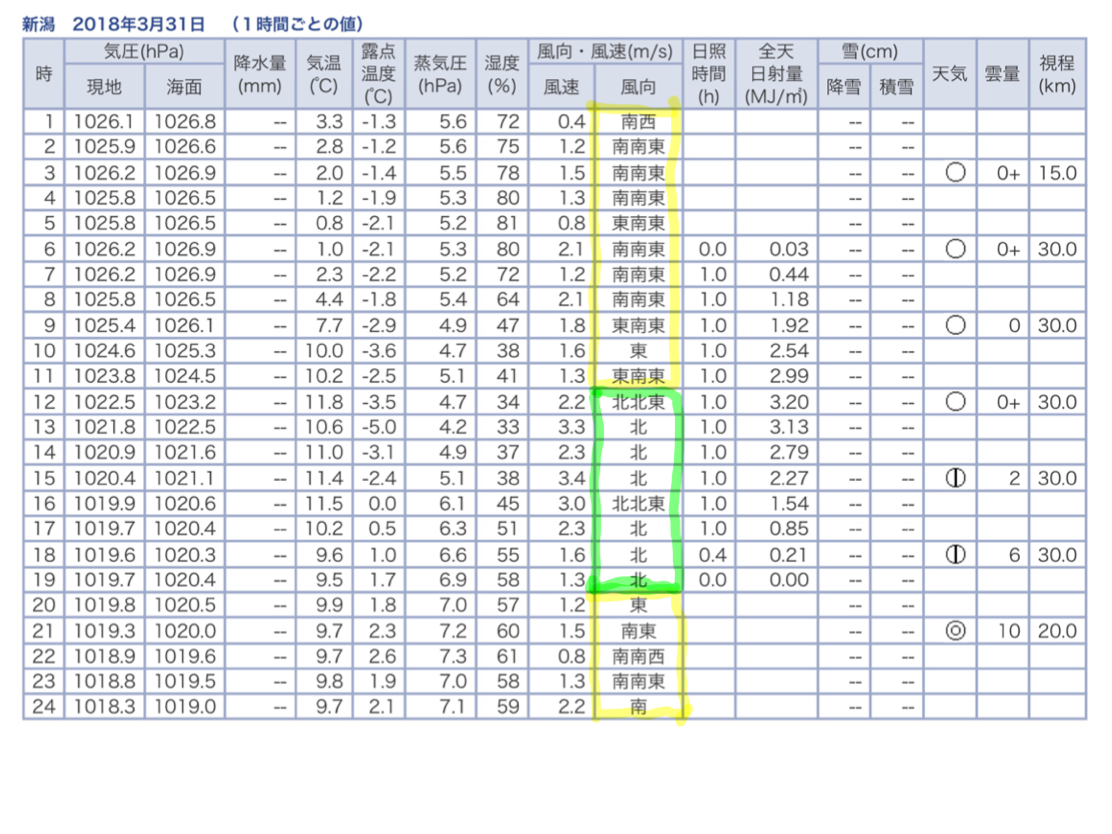 図2 新潟市の時間ごとの気象変化.黄色枠が陸風,緑枠が海風である.
Figure 2 Hourly weather changes in Niigata City. The yellow frame is the land wind, and the green frame is the sea wind.
日本海側のダシの風はしばしば「フェーン現象」と重なって,最近では平成28年の糸魚川大火のような大規模火災の原因となります。また夏場の出穂時期と重なると白穂病という稲作被害をもたらします。
これに対して,東北地方の太平洋側では,日中の冷たく湿った海風が,日本海の低気圧に向かう東風と合わさって,沿岸地方に吹き付けます(図3).これが稲の成長期とくに8月の出穂の時期の日中に吹くとヤマセによる深刻な稲作被害となるのです.
日本海側は夜間から午前中の乾いた陸風が,太平洋側では日中の冷たい海風が稲作に被害をもたらすのです.また,日本海側のダシの風の場合,サッシの窓の普及により建物被害は小さくなりましたが,季節を問わずこれが原因となる大規模火災は跡を絶ちません.なお,日本海側と太平洋側で海陸風の向きが反対になるので,図4に模式図を示しました.
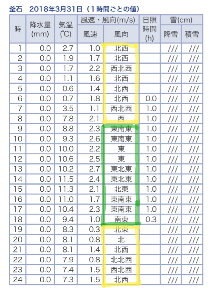
図3 この地方では,午前9時ころからそれまでの西よりの陸風から東寄りの海風に変わるようです.これが午後6時ころの日没時まで続きます.
Figure 3: In this region, from around 9 a.m., the land wind from the west appears to change to a sea wind from the east. This continues until sunset around 6pm.
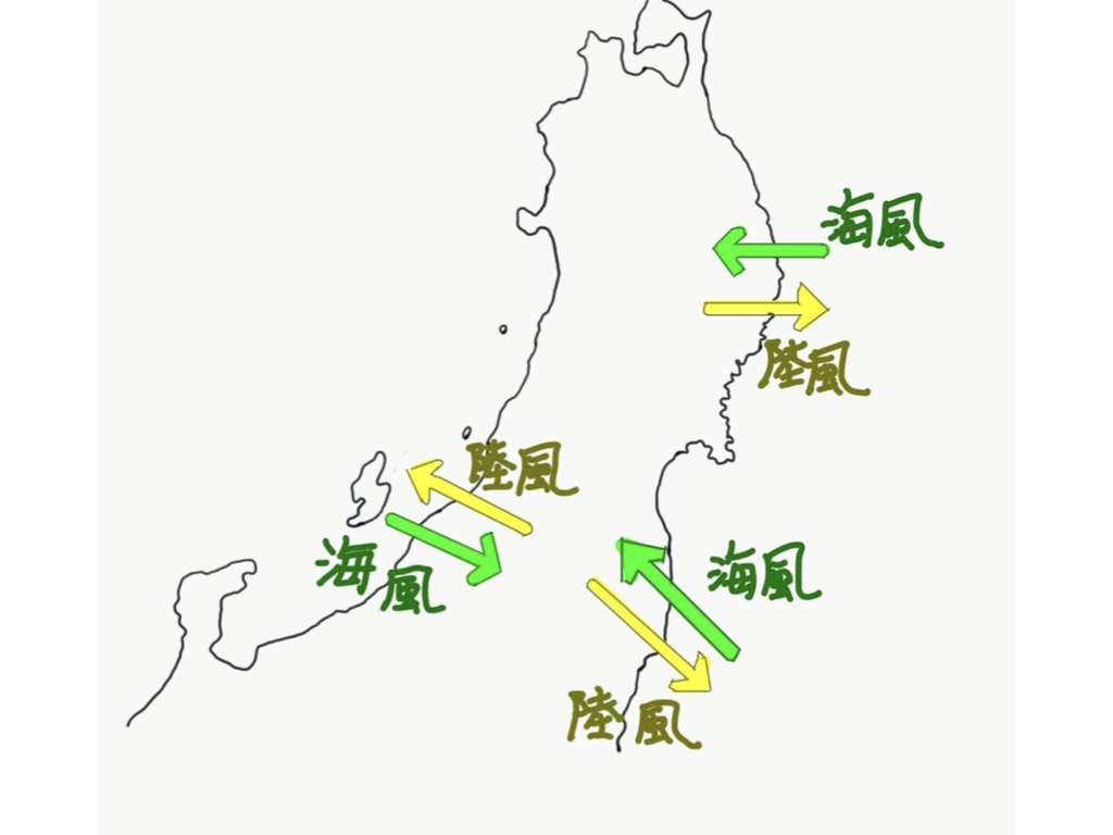 図4. 海陸風は日本海側と太平洋側で吹く向き(風向)が反対になります.夜に吹く風は陸風で,昼に吹く風は海風であることは同じです.また,日本海を低気圧が進んできたときは,日本海側では陸風が,太平洋側では海風が速度の合成の関係で強くなります.福島県浜通り地方の海陸風の図は別ページ(原発災害と海陸風)で説明します.
Figure 4. Land and sea winds blow in opposite directions on the Japan Sea side and the Pacific Ocean side. The wind that blows at night is a land wind, and the wind that blows during the day is a sea wind. Also, when a low pressure system moves through the Sea of Japan, the land wind becomes stronger on the Japan Sea side, and the sea wind becomes stronger on the Pacific side due to the combination of speeds. A map of land and sea winds in the Hamadori region of Fukushima Prefecture is explained on a separate page (Nuclear disaster and land and sea winds).
|
・地震地学のほかに(プロフィール、地学全般その他)に戻る
|
|