日本海東縁プレート境界の地震地学
Seismo-Tectonics on the Eastern Japan Sea Plate Boundary

新潟の地震を考える
My View about Seismicity around Niigata Region

液状化について Liquefaction
2012年2月追加 2024年1月29日更新 

  越後平野の液状化

 地盤の液状化被害は1964年新潟地震で注目されるようになりました.当県では過去にも1828年三条地震の際に長岡,見附,三条,加茂の越後平野中央部が甚大な被害を受けています.
 激しい液状化が生じると,大量の地下水が噴出します.三条地震では,吹き出した水がお湯のように温かかったということです.地下の温度は100m深くなるごとに約3度上昇します.仮に地表付近が10℃として.吹き出した水の温度が40℃とすると,地下1000mくらいの深さから上昇してきたことになります.
 地震がおさまったあと,水は引いてしまいますから,水に伴って出てきた噴砂丘の砂だけが残ります.このため,「噴砂現象」という言葉がよく使われます.しかし,上昇してきた主役は水ですから,むしろ「噴水現象」というべきかもしれません.液状化とは,砂の間隙に取り込まれていた水が,震動によって動きが自由になり,周りの砂粒より軽いために生じる浮力の働きで上昇・噴出する現象です.埋もれ木があればやはり上昇・噴出します.1828年三条地震では大木があちこちの田んぼに浮き上がってきたことが知られています.
 軽い木や水が浮上するのに対して,地上の重い鉄筋コンクリートの建造物は(支持杭がなければ)ズブズブと沈下することになります.
 液状化で川岸町のアパートが傾いたり,昭和橋の橋脚が沈んだりした1964年新潟地震の「そのとき」の様子を調べるため,水を含ませた砂を入れた容器を振動させ,ビルディングに見立てた石材の挙動を調べる実験をしました.  


液状化の実験(動画 mp4形式) を見る
ブラウザによっては動画が再生されないことがあります。


 実験のようす(静止画2枚:動画が再生できない場合のために掲載しました)


タイトル 
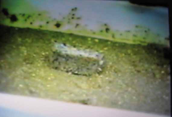
図1. 水を含んだ砂を水平方向に圧縮すると,水は下に沈み表面が乾いた状態になる.その上にマッチ箱大の石材(花崗岩)を載せると,石材は表層の乾いた砂から垂直抗力を受けてつり合う(「浮いた』状態になる).
Figure 1. When sand containing water is compressed horizontally, the water sinks to the bottom and the surface becomes dry. When a matchbox-sized stone (granite) is placed on top of it, the stone receives a vertical force from the dry sand on the surface and becomes balanced (it becomes "floating").


タイトル 
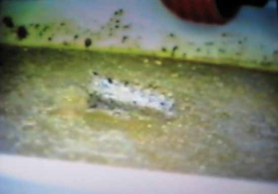
図2.  振動を加えると砂より軽い水は浮き上がり,石は沈下する.
Figure 2. When vibration is applied, water, which is lighter than sand, floats up, and stones sink.


 [著者]
 河内一男 
新潟薬科大学非常勤講師(地学担当)
KAWAUCHI Kazuo
Niigata University of Pharmacy and Medical and Applied Life Sciences ,Part-time Lecturer (Earth Science)

記事一覧
・トップページ 日本海東縁のプレート境界
Top page. Plate boundary on the eastern edge of the Japan Sea[19.6.19]

・新潟県の最近の地震活動
Recent seismic activity in Niigata Prefecture[19.6.19]

・海底地滑りや火山が起こす津波
Tsunamis caused by submarine landslides and volcanoes[19.1.1掲載]

・活断層とは ―重要なところは隠れている―
What is an active fault? -Important parts are hidden-[16.8.11]

・日本海東縁のプレート境界
Plate boundary on the eastern edge of the Japan Sea [16.6.19]

・新潟地震・昭和大橋の落橋
Niigata Earthquake/Showa Bridge collapse

・越後の大津波伝説
Echigo's great tsunami legend[15.9.11]

・越後・佐渡の津波被害,越後の大津波伝説
Tsunami damage in Echigo and Sado, legend of the great tsunami in Echigo

・失われた陸地 ―康平図にある島々の意味―
Lost Land: The Meaning of the Islands in the Kohei Map[12.8.1]

・信濃川地震帯と地形・地質
Shinano River earthquake zone and topography/geology

・地震鳴動(地鳴り)予知された地震
Earthquake rumbling. Predicted earthquake[15.10.13]

・信州大町地震の断層運動
Fault movement of the Shinshu Omachi earthquake[14.11.23]

・三条地震の一つ前の地震 ―「四万石地震」(西蒲原地震)―
The earthquake before the Sanjo Earthquake - "Shimangoku Earthquake" (Nishikanbara Earthquake) -[12.9.1]

・信濃川地震帯の長期予知 ―最悪のシナリオを…―
Long-term prediction of the Shinano River earthquake zone - worst case scenario...[12.8.26]

・小泉其明・蒼軒と三条地震
Kimei Koizumi, Soken and Sanjo Earthquake

・中越・中越沖地震の震源断層
Source fault of the Chuetsu/Chuetsu-Oki Earthquake

・中越沖地震の断層線
Fault line of Chuetsu-oki Earthquake[16.6.30]

・津南町外丸の大崩れ
Massive collapse of Tsunan Town Tomaru [16.5.10]

・液状化について
About liquefaction

・沖積平野下の埋没樹は越後大津波の遺物か
Is the buried tree under the alluvial plain a relic of the Echigo tsunami?[23.9.16]


********* 以下は番外編 *********

・海風と陸風
Sea wind and land wind[19.1.3掲載]

・海陸風と災害
Land and sea winds and disasters[19.1.3掲載]

・海陸風と原発災害の放射線汚染帯
Land and sea winds and radioactive contamination zone from the nuclear power plant disaster[19.1.3掲載]

・どんなときに里雪になるのか
When does it become Satoyuki?[18.1.25掲載]

・これまでの主な論文・最近の学会発表要旨
Main papers and summaries of recent conference presentations

・著者プロフィール、地震地学以外の話題(トップページ)
Author profile, topics other than earthquake geology (top page)