表1,図1,2に佐渡島付近で1月9日,2月7日,15日に発生した2024年1月1日能登地震の余震を追加しました.
このページの目次
○最近の地震活動
○最近の地殻変動
******************** 最近の地震活動 *********************
最近の新潟県内の地震活動のリスト,分布図,M-T図(いずれも1990-2019年, M>=4.5)です.基礎データは気象庁・防災科研・東大地震研等の速報値または暫定値です.これらをもとに筆者の責任で整理したものです.通し番号7・10・14・20の被害地震の余震は除外しました.2014年4月8日に発生した地震は続報でM4.4に下方修正されていますが,参考のためそのまま載せてあります.2024年1月1日能登半島地震(M7.6)の震源域(余震分布)は西北西に延びて,佐渡島二見半島の沖合に達しています.
「最近」という言葉は,気象庁の観測精度の向上や情報の公開が進んだこの20-30年間という意味で使っています.被害地震の長期予測を考える場合はこの期間の活動を見ただけでは不十分です.当サイトでは日本海東縁のプレート境界のページで,過去70年間程度の中部地方の,また新潟県内については史料が残っている過去400年間程度の地震活動履歴を紹介しています.
巨大津波については過去400年間でも不十分です.おそらく,この地方の巨大津波は500年-数1000年の間隔をおいて襲来します.これについては,失われた陸地 ―康平図にある島々の意味―または,越後の大津波伝説のページをご覧ください.
表1 地震リスト(1990〜2024年 M>=4.5).最新データは防災科学研究所による. データは自動計算のため、各種数値は暫定値である. Table 1 Earthquake list (1990-2024 M>=4.5).The latest data is from the Disaster Prevention Science Research Institute. Since the data is automatically calculated, various numerical values are provisional values. 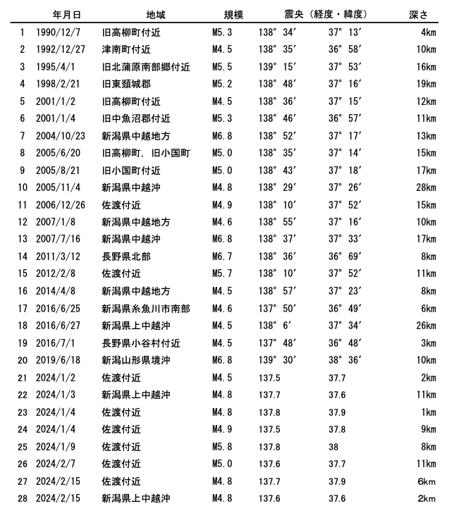
この表では緯度経度を60進法(小数点以下を分単位)で表記しています.これは図面製作に国土地理院地形図を利用したためです.下の図9においては,中小規模の地震が主体なので,図2,3のような震源の広がり方は表現せず,規模を円の大きさで示しました.2004年,2007年,2011年,2019年の余震は割愛しました.2024年(能登半島地震)の佐渡付近の余震は当面掲載します.なお,この余震のデータはHi-net自動震源情報によるため,気象庁の速報値とは一致していません
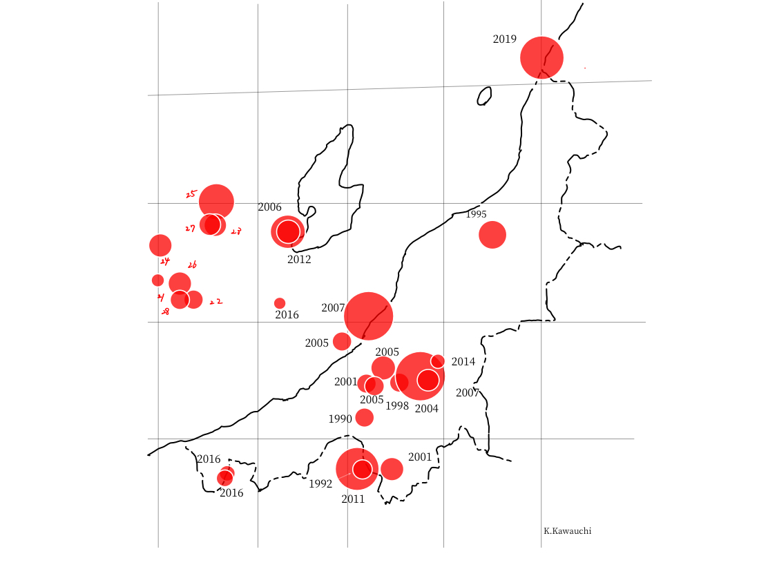
図1 分布図(1990〜2024年 M>=4.5).
Figure 1 Distribution map (1990-2024 M>=4.5).
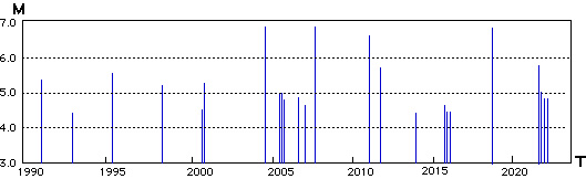
図2 M−T図(規模と時間の図,1990〜2024年 M>=4.5)
Figure 2 M-T diagram (scale and time diagram, 1990ー2024 M>=4.5)
********************* GPS測量による最近の地殻変動 **********************
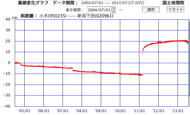
最近(2004年7月1日〜2013年7月27日)の佐渡-三条間の土地の伸縮運動
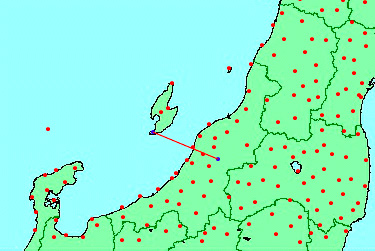
図3 上のグラフは下の地図の佐渡市小木・三条市下田二点の間の基線の過去10年間の伸び縮みを表しています.〔国土地理院HPによる〕
Figure 3 The upper graph shows the growth and contraction of the baseline between Ogi, Sado City, and Shimoda, Sanjo City, on the map below, over the past 10 years. [According to the Geospatial Information Authority of Japan website]
|
〔解説〕2011年3月の東北地方太平洋沖地震が発生する前までは,年あたり約1cmで短縮していましたが,この地震で約20cm伸長しました.その後も余効変動が続いていましたが2013年7月現在は,旧に復しつつあります.2004年10月と2007年7月に急な短縮が見られるのは,それぞれ中越地震,中越沖地震の断層運動によるものです.
中越地震と中越沖地震では基線(佐渡小木ー三条下田)を横切る位置に,太平洋沖地震では基線の東方に断層線があり,いずれも震源断層が断層付近で土地が短縮する逆断層であったため,前者の二つでは短縮し,後者では伸張したものです.
データの更新(2006年6月5日〜2016年6月18日)
図4 図3のデータを更新した〔国土地理院HPによる〕.2011年の地震の余効変動は依然続いています.現在,伸縮は概ね平衡状態です.
Figure 4 The data in Figure 3 has been updated (according to the Geospatial Information Authority of Japan website). Aftereffect fluctuations of the 2011 earthquake are still continuing. Currently, expansion and contraction are approximately in equilibrium.
|
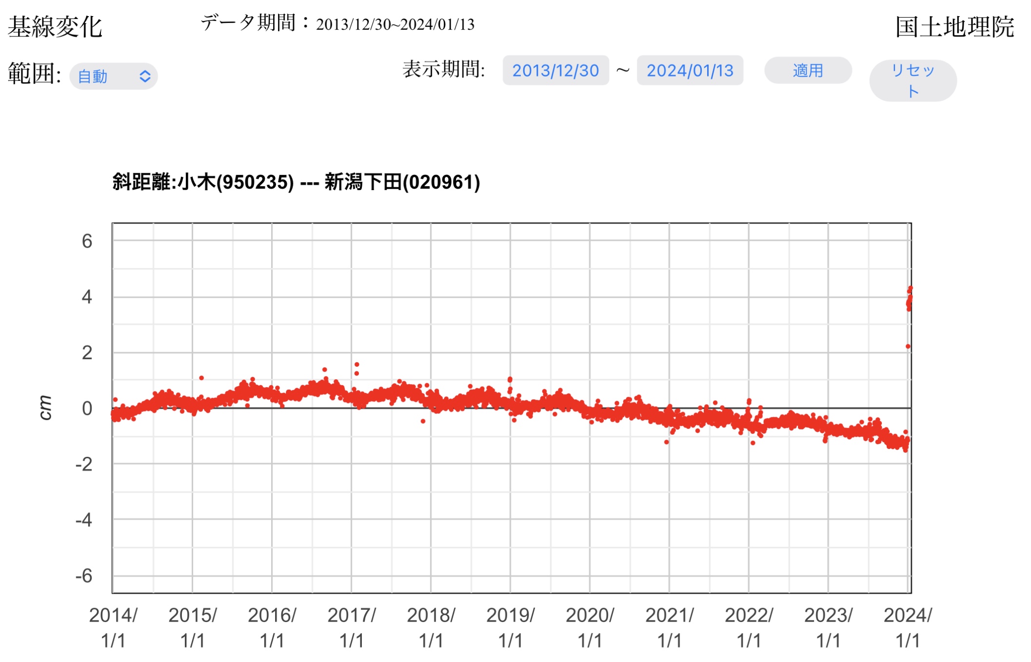
最近のデータの更新(2013年12月30日〜2024年1月13日)
図5 図4のデータを更新しました〔国土地理院HPによる〕.短縮の傾向に戻ったように見えます.グラフの右端(24年1月1日〜13日の打点)で能登半島地震の影響が認められます.すなわち,断層線に近い小木が三条下田に対して約5cm西へ移動しました(基線が5cm伸びた).これは,東傾斜逆断層の上盤にある佐渡島が西方へのしあがる変動をした(あるいは,西傾斜逆断層の下盤にある佐渡島が西方へ潜り込む変動をした)ことを意味しています.下は1月1日をはさむ約1ヶ月の変動です.
Figure 13 The data in Figure 12 has been updated (according to the Geospatial Information Authority of Japan website). It appears that the trend of shortening has returned. The influence of the Noto Peninsula earthquake can be seen at the right end of the graph (dotted points from January 1 to 13, 2024). In other words, the Ogi near the fault line moved approximately 5 cm westward with respect to Sanjo-Shitada(Baseline increased by 5 cm ).This means that Sado Island, which is located in the upper block of the east-dipping reverse fault, has upheaved westward. Alternatively, it could mean that Sado Island, located on the lower block of the west-dipping reverse fault, has sunk westward. Below is the fluctuation for about a month including January 1st.
|
| |